
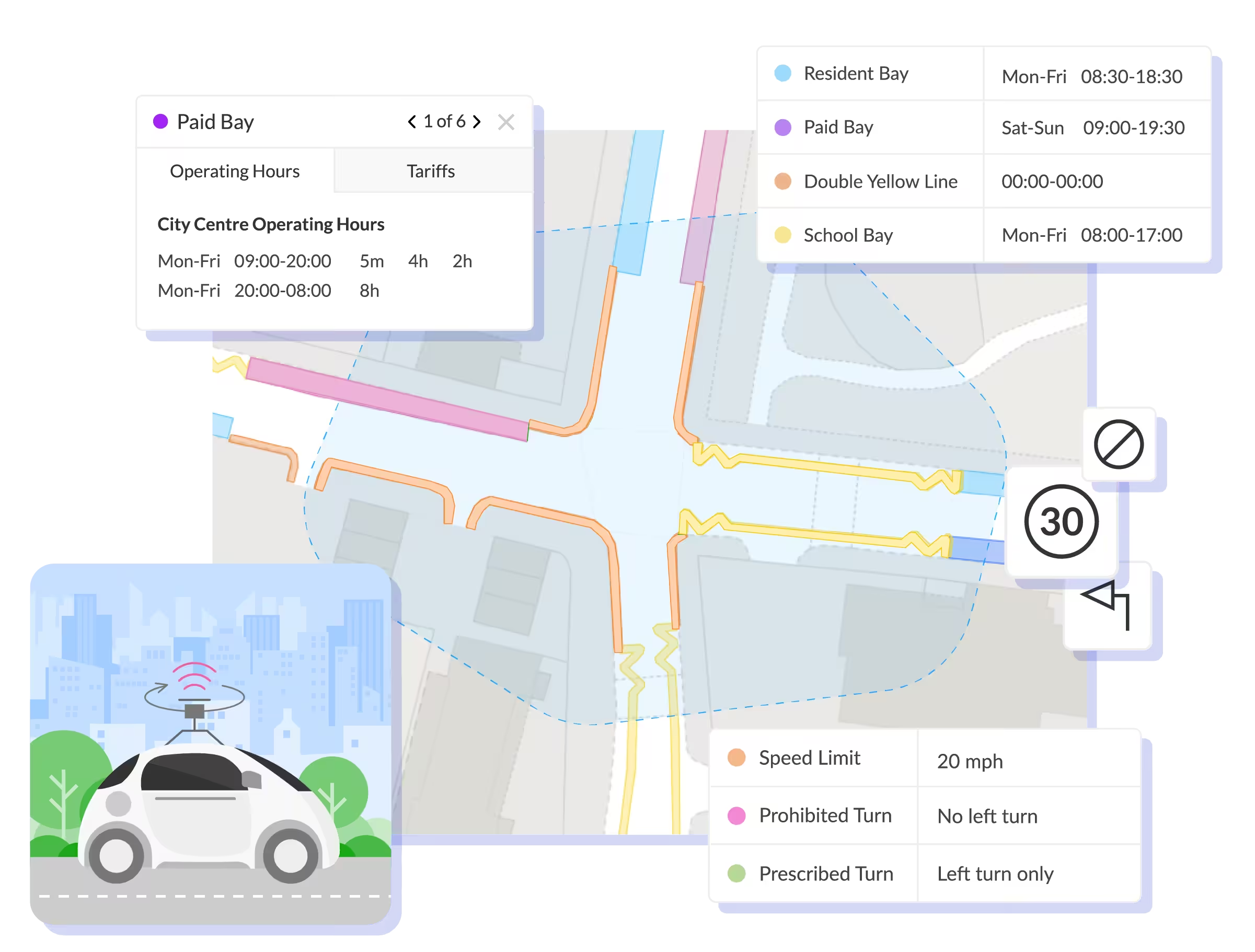
Industry-leading LiDAR, photographic and machine learning survey solutions to efficiently capture kerbside assets and restrictions, enabling map-based TRO management
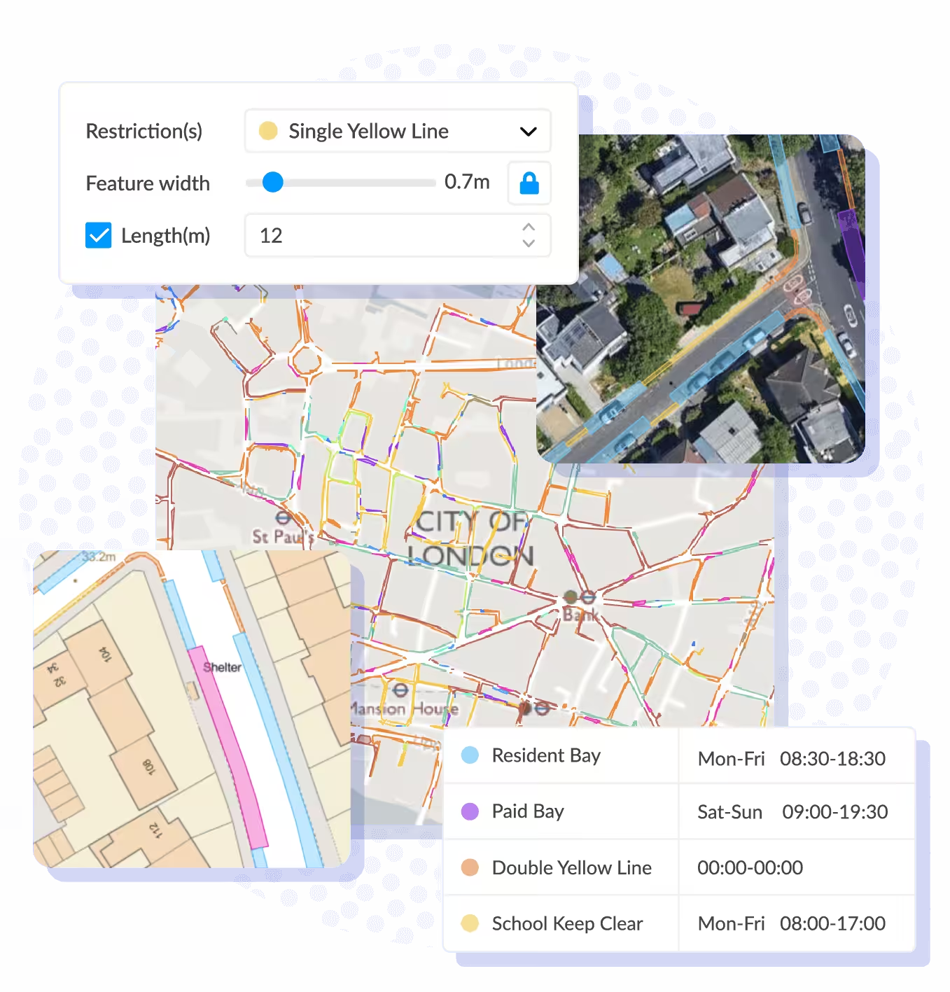
Reflect exactly what's on-street with 3cm data accuracy
Data capture and extraction delivers highly accurate ‘digital twin’ of kerbside assets and parking restrictions, providing the foundations for public friendly map-based TRO management.
-
Parking restrictions: Manage incoming requests through a standardised form, decision log and notifications
-
Traffic restrictions and plates: All parking plates, exit/entry signs, and more
-
Loading/Waiting information: Single yellow lines, double yellow lines, and kerbs marks
Realise more value with faster data capture and extraction
Combining multiple survey and extraction technologies delivers valuable TRO data into the hands of local authorities faster.
- Up to 100kms captured every day: On-vehicle and on-foot solutions ensure all road networks are mapped quickly, affording multiple passes to verify gaps when necessary.
- LiDAR and optical surveys deliver more value: High-quality data and photographic Imagery captured at approximately 1 to 3 metres along route, with 50+ additional features extractable, including maintenance condition flags for street signage.
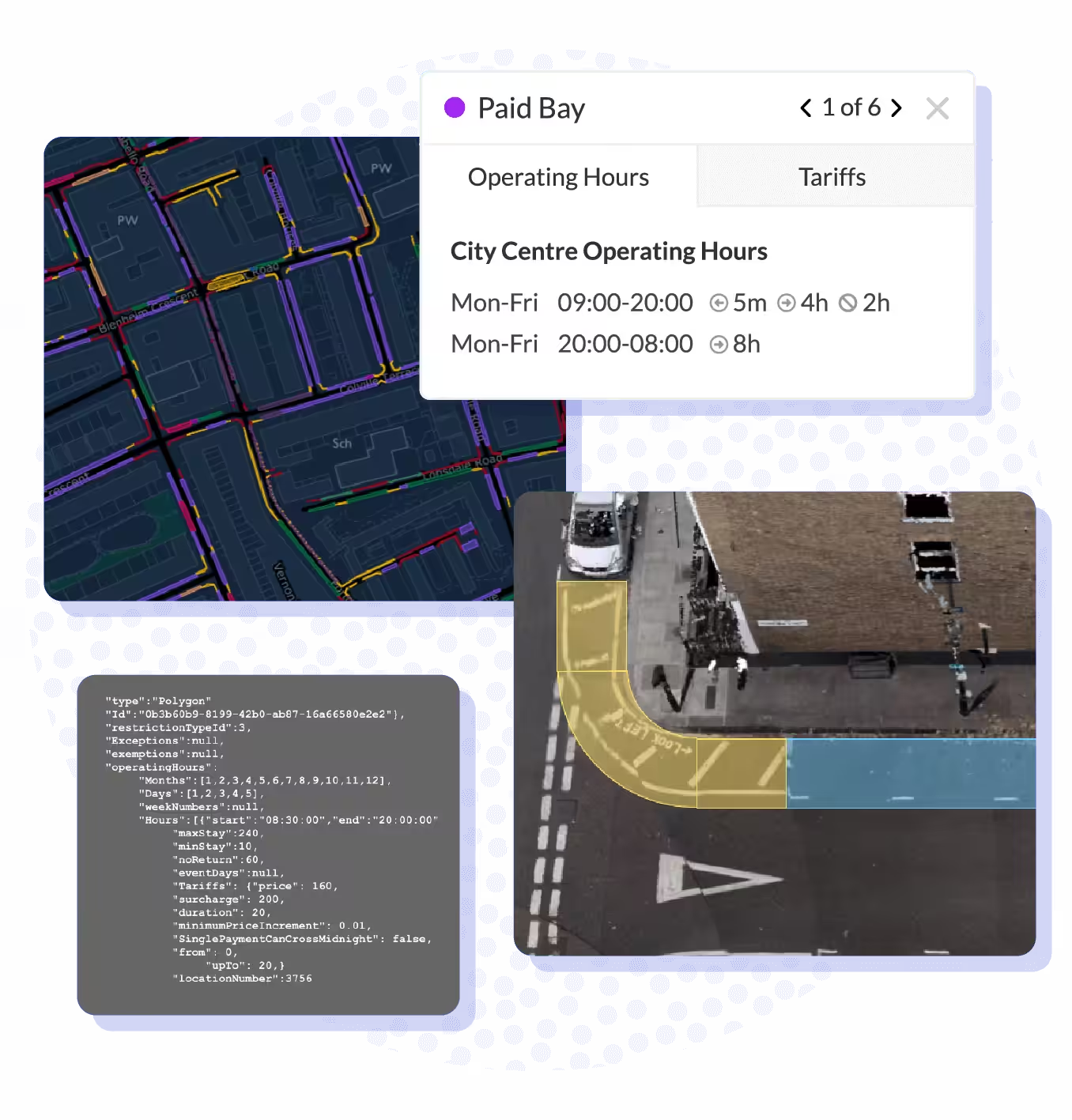
- Supporting your journey to consolidated orders: Post-survey and data extraction, our dedicated team uploads TRO data into Mapper and supports you through quality assurance and creation of your first consolidated traffic orders.


Frequently Asked Questions
What is the AppyWay Surveys service?
It is a high-tech mapping service that creates a highly accurate ‘digital twin’ of your kerbside. We use advanced LiDAR, photographic, and machine learning technologies to capture and digitise all on-street assets and parking restrictions, forming the foundation for modern, map-based traffic order management.
How does the data capture process work?
Our teams use specialised vehicles to survey your road network. This technology captures high-resolution imagery and data with 3cm accuracy, covering up to 100km of road every day for maximum efficiency.
What happens to the data after it's captured?
The captured data is processed using a combination of machine learning and artificial intelligence to extract every detail. Our specialist teams then perform rigorous quality checks to ensure pinpoint accuracy before uploading it into the AppyWay platform.
What are the main benefits of using this service over traditional surveys?
The primary benefits are speed, accuracy, and cost-effectiveness. Our technology-led approach delivers a more accurate and comprehensive dataset in less time and at roughly half the cost of traditional, manual survey methods.
What kind of data can be extracted?
Beyond standard parking restrictions and bay types, Appyway’s surveys can extract over 50 additional features. This includes details like the maintenance condition of street signs, the location of street furniture, and other crucial kerbside assets.
How does this service help with your Traffic Regulation Orders (TROs)?
The survey provides the definitive, accurate baseline of what is physically on the street. This is the crucial first step to creating new or consolidated traffic orders, ensuring your digital records perfectly match the real world and meet the highest standards of compliance.
What support do you get after the survey is complete?
After the data is extracted, our dedicated team will upload the TRO data into the AppyWay platform. We then support your team through the quality assurance process and help you create your first new or consolidated digital traffic orders, ensuring a smooth transition.
Surveys
We deliver speed and accuracy at half the cost of traditional surveys
Our expertise in reducing the gap between what’s on the road and in records is why local authorities pick us for digitising their traffic orders.
360° Imagery
Specialised vehicle-mounted cameras capture high definition photographs every meter to ensure high accuracy and coverage of roads.
Pinpoint Accuracy
All imagery is date and timestamped, whilst providing full geographically referenced positional data using global mapping standards.
Superior Extraction
Data extraction process involves a combination of machine-learning, artificial intelligence and stringent quality checks by specialist teams for precise results.
Data Experts
We analyse every street, ensuring rigorous standards of data are met and traffic orders match highest level of compliance.
Built for todays’s challenges
Explore our traffic order suite
 Award winning software to manage static, moving and experimental traffic orders with teams.
 Car park and estate order management and data sharing, contextualised with on-street regulations.
 Share proposed traffic orders, collect feedback and analyse responses from the public.


 Promote public engagement in active travel, electrification and decarbonisation discussions.
 Efficiently capture kerbside assets and restrictions, enabling map-based TRO management.

Ready to digitise your streets?
Reach out to schedule a personalised demo with our traffic order specialists. We’ll show you how our Surveys work and send you a sample of the data we collect.
You're in great company
Join some of the local authorities below that are using AppyWay to power their traffic order management.