Region
London Borough of Lambeth

David Eaglesham
Head of Service Development & Street Management
Lambeth Council is located south of the River Thames in London. It boasts a robust public transport system, although it faces challenges with overcrowding during peak hours. Approximately 50% of households in Lambeth do not own a car, reflecting a strong opportunity for sustainable travel.
The council has initiated progressive transport policies, including Healthy Neighborhoods and a Kerbside Strategy to reallocate road and kerb space to promote sustainability. The Kerbside Strategy sets out their ambitious plans to transform 25% of Lambeth’s kerbside space into sustainable use, encompassing everything from EV charge points, parklets, cycle hangars and more.
In the past, Lambeth Council managed traffic orders through text-based schedules, creating administrative bottlenecks and making it challenging for designers to accurately reference existing restrictions. The disconnect between documented orders and actual street conditions often led to design proposals that didn’t properly align with current regulations.
The process of cross-referencing traffic orders and collating feedback during consultations was slow, often taking 3-4 months to complete. This inefficiency hindered timely project implementation and made it challenging to ensure that all public representations were accurately considered. The absence of Traffic Order software created significant delays and complications in managing traffic orders effectively.
The council faced a dual challenge: they needed to streamline their Traffic Management Order process with better organised, shareable data, while also developing a way to monitor kerbside changes to measure progress toward their sustainability goals.
Lambeth Council utilised two key solutions from AppyWay to enhance its traffic management capabilities: Traffic Suite and KurBi. Lambeth began the data creation process with AppyWay in January 2022 and was fully operational by June 2022.
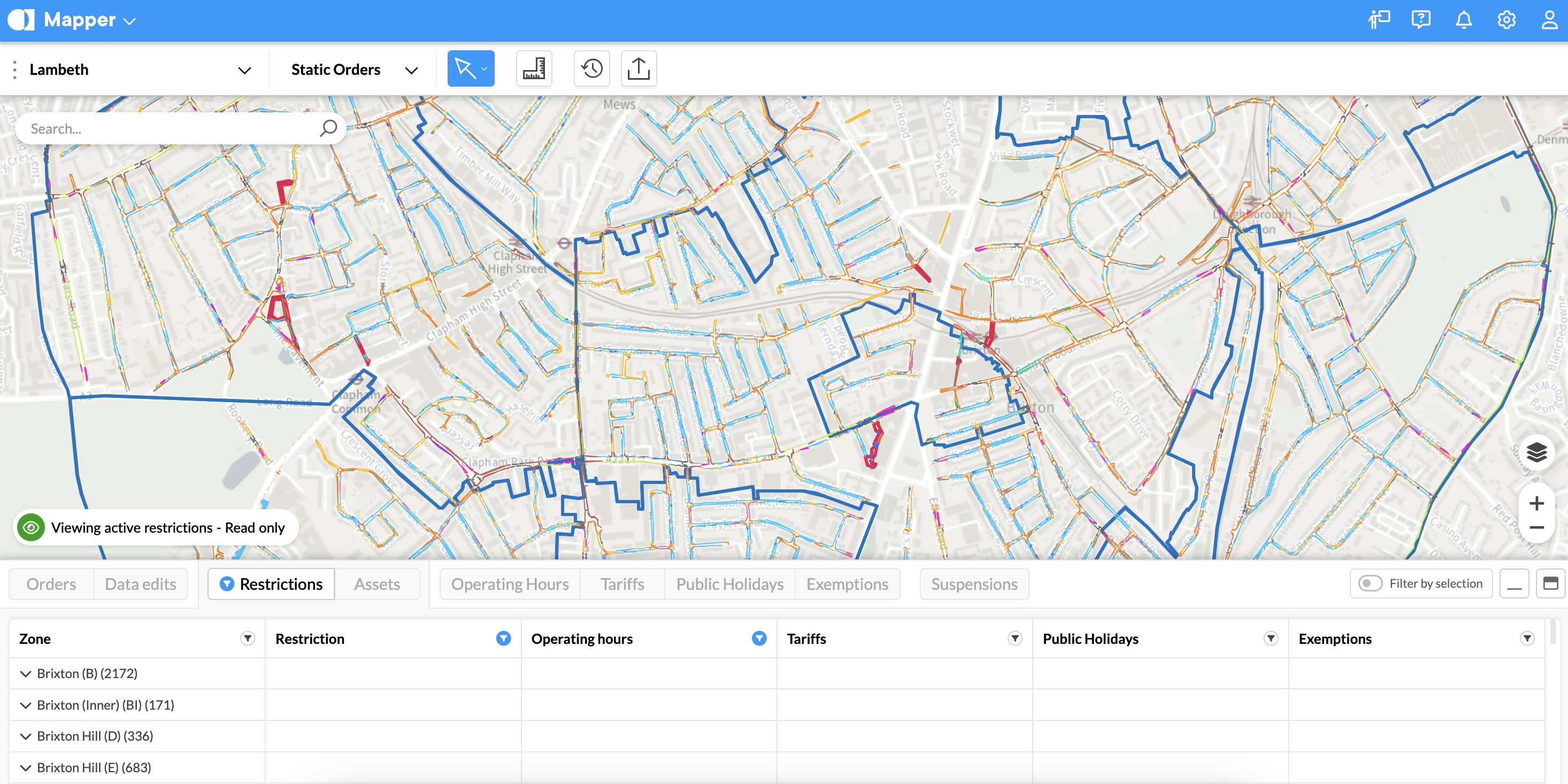
The Traffic Suite streamlines the Traffic Management Order (TMO) process by providing a centralised, visual mapping system that clearly displays parking restrictions and kerbside uses. This makes it easier for designers and enforcement teams to work with accurate information.

Lambeth’s highly accurate digital traffic order data as seen in Traffic Suite
”Traffic Suite Mapper Module's mapping capabilities have made it much easier for our internal design teams to interrogate the restrictions and for designers to base their proposals on existing legal controls, which is very helpful in ensuring there are no overlapping problems.
David EagleshamHead of Service Development & Street Management, Lambeth Council
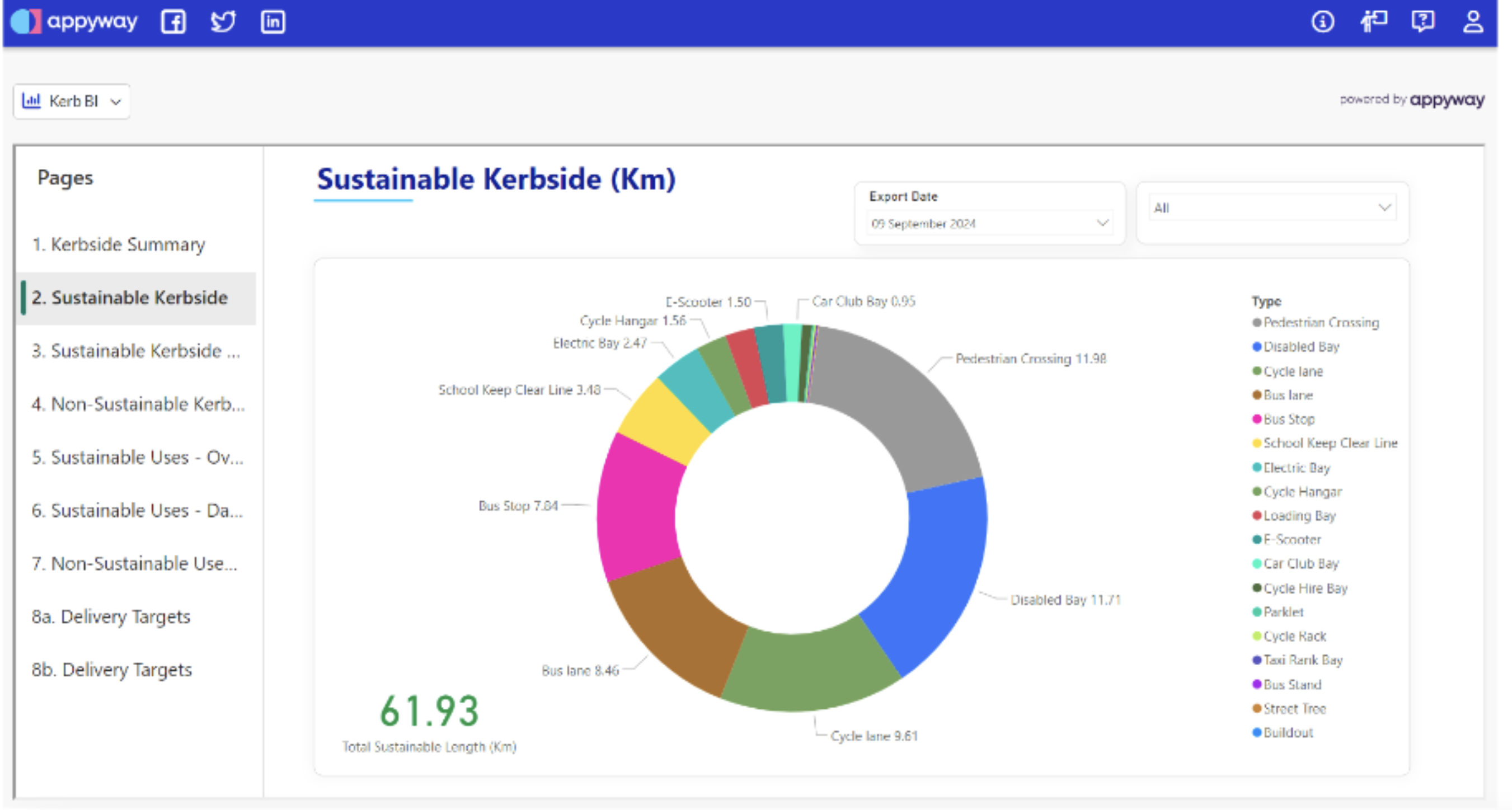
The KurBi module specifically assists in monitoring progress on Lambeth’s Kerbside Strategy, which aims to reallocate 25% of kerbside space for sustainable transport uses.

Overview of Lambeth’s sustainability goals tracking in Kerb BI

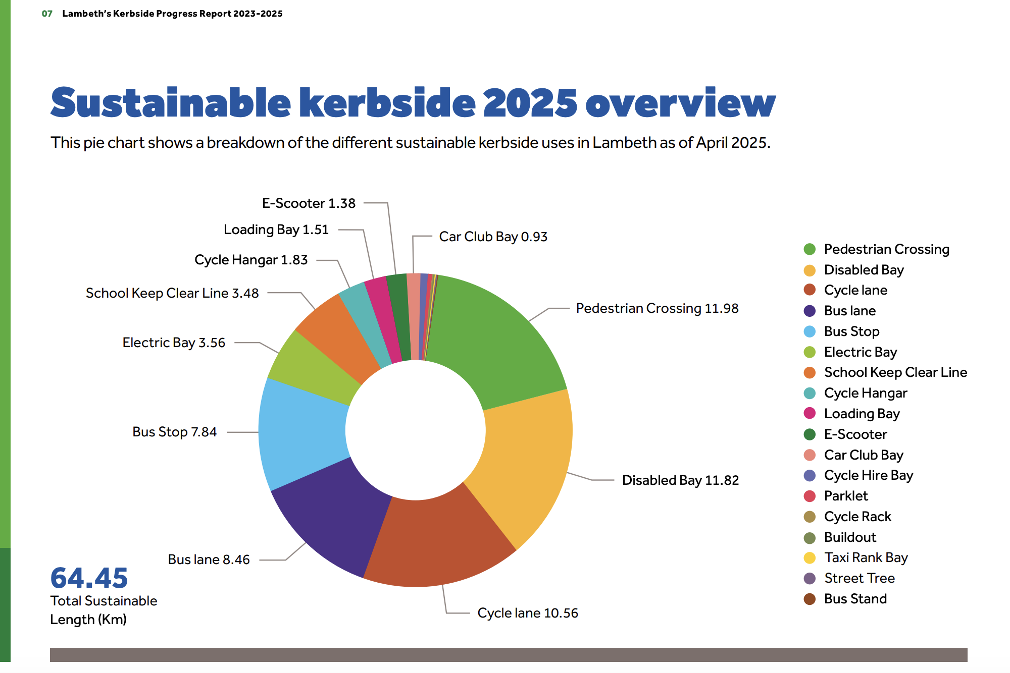
Source: lambeth.gov.uk

KurBi data used in the Kerbside Strategy progress report
”KurBi helps us monitor the progress of our program delivery (Kerbside Strategy), and it works closely with the Traffic Suite system. It has been very beneficial for our colleagues in the Transport Team to report on the program’s progress. KurBi provides a simple to understand reference of the current state of Lambeth's kerbside' work. It makes it really straightforward to interrogate how it's been used and review progress with implementation.
David EagleshamHead of Service Development & Street Management, Lambeth Council
”Moving from text-based orders to digital mapping is a big change, but it is also a big opportunity to refresh traffic orders and remove historical discrepancies, resulting in a clean slate that reflects what exists on the ground.
David EagleshamHead of Service Development & Street Management, Lambeth Council
The Traffic Suite system provided a mapping-based interface that made it much easier for users to understand and visualise the traffic restrictions. The mapping-based approach was seen as a huge improvement over the previous text-based system, as it aligned with the way people are familiar with using online mapping platforms.
Traffic Suite software allowed Lambeth to consolidate all traffic order information into a single, centralised system. This provided a common source of information for designers, order makers, and enforcement teams, reducing discrepancies and errors.
The Traffic Suite system made it much easier for internal design teams to interrogate existing restrictions and base their proposals on accurate, up-to-date information.
This reduced the time and effort required to cross-reference orders and schedules, as well as the risk of overlapping problems or errors in the proposals.
The improved visibility and accessibility of the traffic order information through the Traffic Suite system resulted in fewer queries and freedom of information requests from the public.
Get the traffic order suite built for today’s challenges.