Region
London Borough of Lambeth

This is a particular benefit of the whole Appyway platform: that it has a public component which makes it easy for our residents to view how our Kerbside is used by looking at a map.
Tash Hartke. Kerbside Strategy Programme Manager Transport and Public Realm, London Borough of Lambeth
Lambeth’s kerbside data viewed in KurBi dashboard
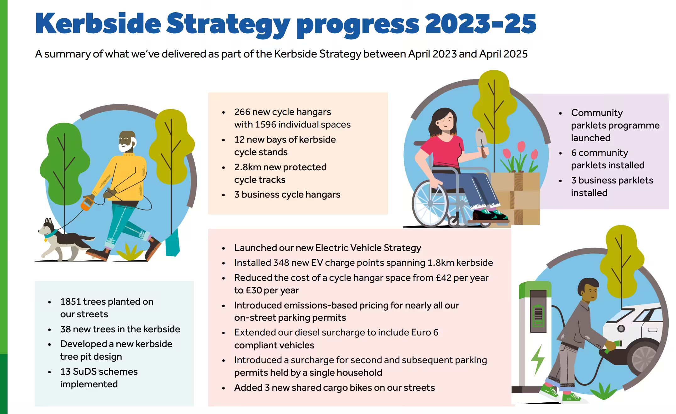
Lambeth Council is widely recognised for its commitment to progressive transport policy, encapsulated by its ambitious Kerbside Strategy. The goal is to reallocate 25% of the borough’s kerbside space for sustainable uses, including cycle hangars, EV bays, and parklets.
Following the successful digitisation of their Traffic Orders (D-TROs) using AppyWay’s Traffic Suite, the Council’s focus shifted to building a robust, transparent system capable of tracking, measuring, and communicating the impact of this large-scale strategic shift.
Holistic Data Integration: Combining legal Traffic Order data with non-TMO assets (like parklets and trees) was a complex task
Manual Reporting Burden: Producing essential progress reports, such as the Kerbside Progress Report, was administratively intensive due to the manual collation of data from disparate systems.
Lack of Visual Clarity: Consistently translating complex kerbside changes into a simple, visual format was difficult, limiting easy communication with the public and non-technical stakeholders.
Successfully delivering a wide-ranging Kerbside Strategy requires constant monitoring to ensure that delivery targets are met and high-level strategic objectives are being realised. Lambeth faced the critical challenge of translating complex, geospatial kerbside data into clear, actionable progress reports for internal teams, elected members, and the public.

Source: lambeth.gov.uk
Lambeth Council deployed AppyWay’s KurBi (Kerbside Intelligence) module, a dedicated Business Intelligence tool for digital kerbside data, to serve as the central engine for monitoring the Kerbside Strategy.
KurBi automatically ingests information directly from Lambeth’s public-facing digitised traffic orders and displays this in a dynamic, visual dashboard. Crucially, the platform provides the flexibility needed to address the Council’s unique strategic requirements:
”The flexibility of Mapper & KurBI in being able to add non-traffic-order shapefiles, such as Kerbside trees or parklets, helps us to monitor specific components of our Kerbside Strategy under our priorities of Increasing Climate Resilience and Creating Places For People.
Tash HartkeKerbside Strategy Programme Manager Transport and Public Realm, London Borough of Lambeth
By using KurBi to monitor and report on its strategy, Lambeth Council has transformed its ability to track progress, plan resources, and maintain public transparency.
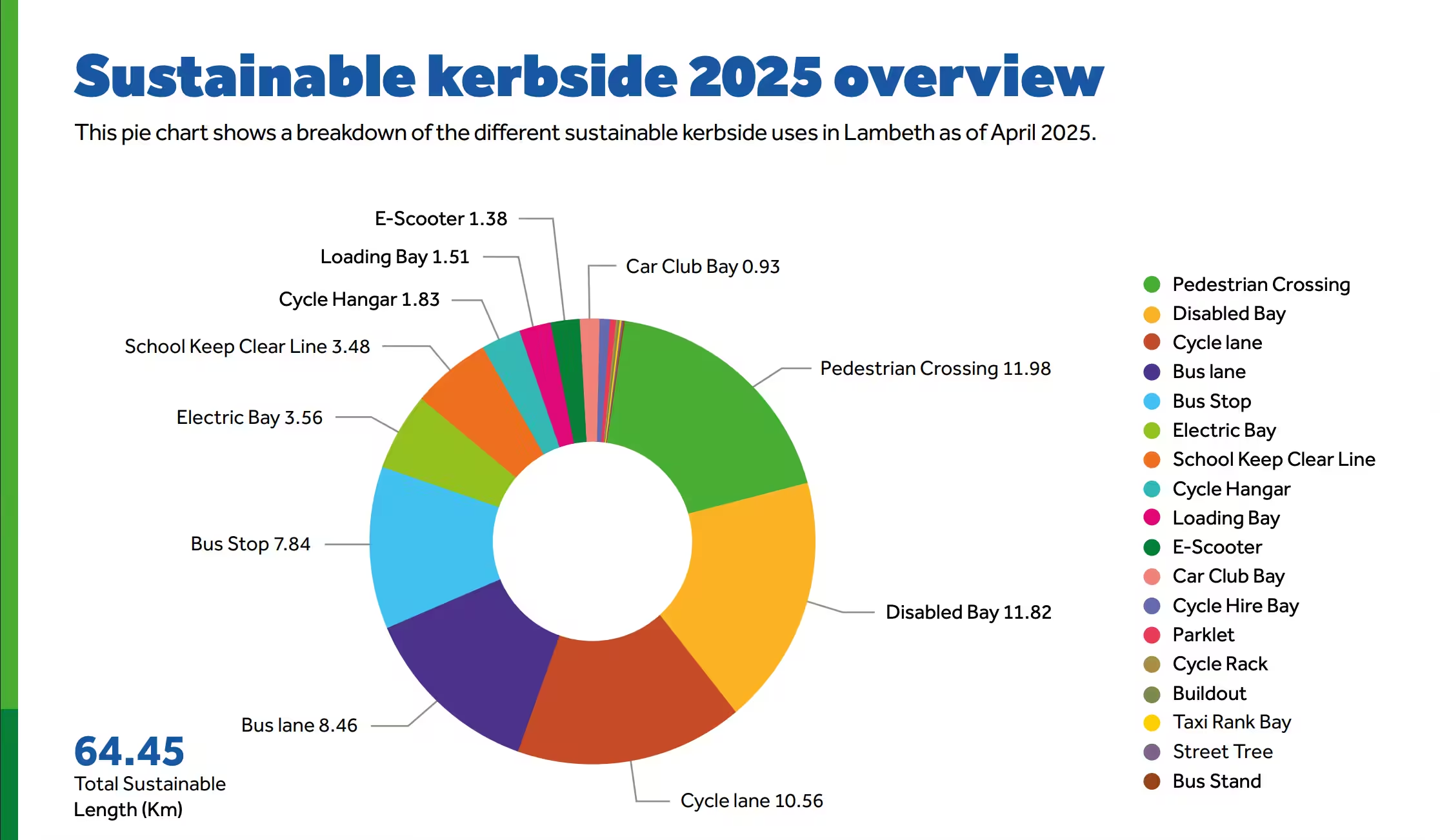
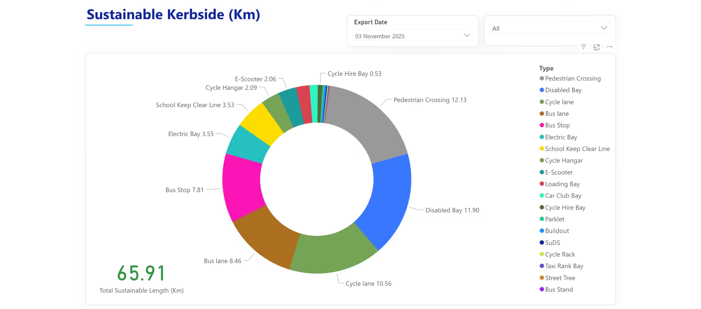
KurBi data used in Lambeth’s Sustainable Kerbside report
KurBI instantly compiles comprehensive data, significantly reducing the administrative burden of producing key strategic documents like the Kerbside Progress Report.
Progress is displayed in simple, visual charts, making key metrics on kerbside use easy for non-technical stakeholders and the public to understand.
The connection to the public-facing AppyWay platform provides residents with map-based transparency on kerbside usage.
KurBi aids resource management by clearly identifying delivery progress against targets, highlighting areas that require resource reallocation or plan adaptation.
Get the KurBi module built for today’s challenges.
![]()
Aldwych House,
71-91 Aldwych, London,
WC2B 4HN
© Copyright AppyWay. All Rights Reserved. Privacy Policy | Cookies Policy